This is a simple export. However, some setup is required:
- Establish the following Customer Classifications:
- Wholesale Customers – Customers who resell product to an end user should be added to a Wholesale Customer Classification. This group is excluded from reporting.
- Nitrogen Stabilizers – Any nitrogen stabilizer Products should be added to the Nitrogen Stabilizer Product Classification. If Products exist in multiple Locations, each nitrogen stabilizer Product in each Location must have this Classification.
- Establish the following Product Classification:
- Custom Application – Associate any application service item (spraying, spreading, etc.) to the Custom Application Product Classification. Again, include application service items from all Locations.
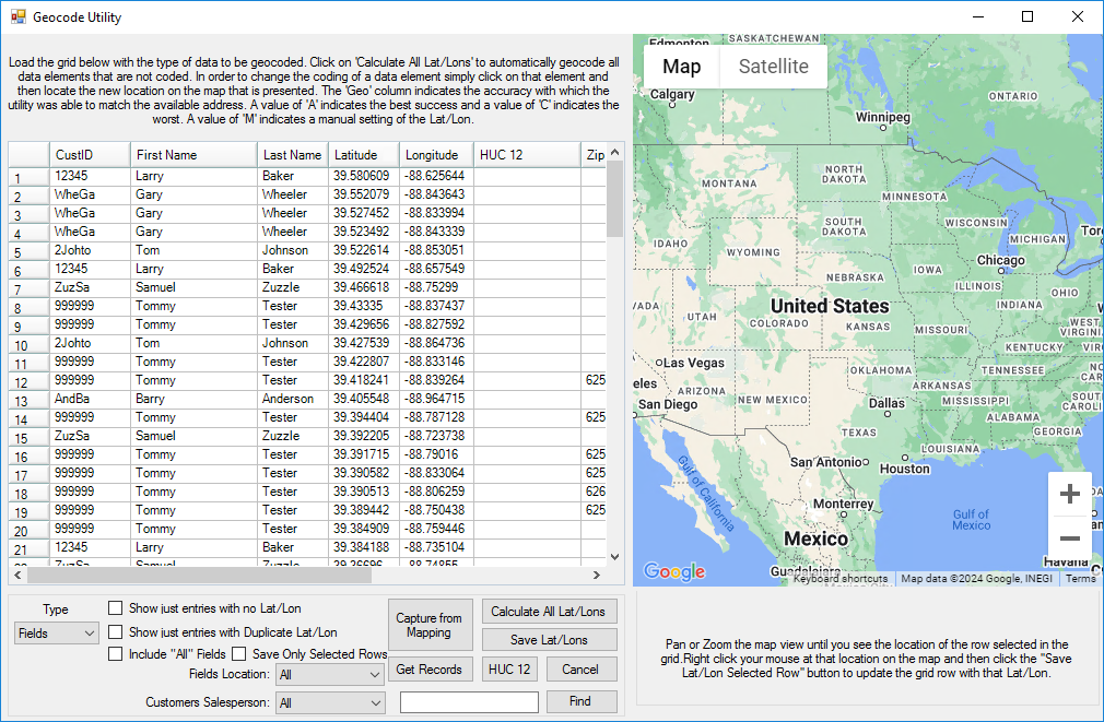
- To help associate Fields to their corresponding watershed, Fields must first be geo-coded with the Latitude and Longitude at the Field Profile screen. A utility found at Hub / Setup / Geocode Agvance Data provides the quickest, most accurate way to assign a latitude and longitude to a group of Fields. The USGS defines watershed boundaries in terms of six nested levels of hydrologic unit codes (HUC). The Geocode Agvance Data utility can automatically assign fields to the appropriate HUC-12 code if the Field has a valid latitude and longitude. At the Geocode Utility, select Fields as the Type and choose Get Records to bring the Fields into the grid. Select HUC 12 to automatically fill the HUC 12 column. Choose Save Lat/Lons to save the new HUC codes on the field.
- The USGS defines watershed boundaries in terms of six nested levels of hydrologic unit codes (HUC). HUC-2 is the largest region. For example, the Pacific Northwest region 17 covers 273,647 square miles. HUC-12 is the smallest level, called a subwatershed, generally covering 10,000 to 40,000 square acres. An example of a subwatershed is the South Fork Imnaha River Subwatershed, which is located within the Pacific Northwest region and is coded 170601020101 with every two digits signifying a smaller portion of the region defined by the preceding digits.
- The Geocode Agvance Data utility can automatically assign Fields to their appropriate HUC-12 code with the only requirement being the Field having a valid lat/long. Select Fields as the Type, then choose Get Records to fill the grid with all Fields. Select the HUC 12 button to automatically fill the HUC 12 column. Choose Save Lat/Lons to save the new HUC codes back to the Field Profile screen.

Creating the Export File
The text file created by this export reports nitrogen and phosphorous Products in pounds of plant food and nitrogen stabilizer Products in pounds of Product. It includes the date of application, the HUC-12 code if available, the county and state associated with the Field, and the acres and crop recorded with the transaction. A Y or N indicates if the product was custom applied.
At Accounting / Transfers / Export / Watershed Applications, complete the screen with a convenient network path to store the export file, the range of Invoices to scan, and select the applicable Classifications.
Hint: By selecting Save Set, the Export Folder and Classifications can be consistently selected with each export.

If an Invoice originated from Blend or Delivery Tickets, the export uses data from the tickets. Any additional N, P, or Stabilizer Product added at the time of invoicing those tickets is also reported. Each reportable line item makes a record in the export file. The ticket number and a ticket type indicator is associated with each record (B for Blend, D for Delivery, I for Invoice).
A Validation Report is available which lists the Customer and Field associated with a Ticket/Invoice as well as a recap of ticket types, breakdown by HUC, and percentage breakdown of geo-referenced versus non-geo-referenced transactions. The transactions are listed in the same order they appear in the export file which is helpful when validating the data in the export file.
The resulting export file is named Watershed_Agvance_xxxxxxxxx_yyyymmdd.txt where xxxxxxxxx is the Retailer IC Code entered on the Company Setup screen (found at Hub / Setup / Company). The date helps distinguish the file from previous files. A file created on the same day as another will overwrite any file made earlier in the day.
The resulting files are aggregated by a third party. For instructions on submitting the file, contact the state agency that oversees this process.
Illinois Retailers:
Email file to:
PAQ Interactive, Inc.
ATTN: Quentin Rund
qrund@paqinteractive.com
Transaction Guidelines
To optimize the success of the nitrogen and phosphorous application monitoring, the following are the recommended best practice guidelines:
- Use Geo-Referenced Field on Tickets – Develop a procedure to ensure as many tickets as possible have a geo-referenced field. If this information is not known when the product goes out initially, collect the information after application. Using the Combine/Split Delivery Ticket feature, replace the original ticket with ticket(s) that specify the Field. This export, and perhaps more importantly the Field History report, will have more value.
- List Crops on Transactions – Develop a company-wide policy to ensure crops are reported consistently on transactions. It is suggested to note the crop to which the fertilizer is contributing. For example, for fall application after crop removal, name the crop that will likely be planted on that field the following year.
